Bankhead National Forest
(The Warrior Mountains)
Hiking in Bankhead
Canoeing In Bankhead
Located in northwestern Alabama, the William B. Bankhead
National Forest offers something for everyone. The Bankhead's 180,581 acres, occupying
portions of Winston and Lawrence Counties, offer scenic beauty, majestic trees, recreation
opportunities and abundant wildlife.
Originally designated on January 15, 1918 under the name
"Alabama National Forest", Congress enacted legislation in 1942 changing the
name to William B. Bankhead National Forest. This change was made to honor one of
Alabama's most distinguished native sons, William B. Bankhead, who served in the U.S.
Congress from 1917-1940 and was Speaker of the House from 1936 until his death in 1940.
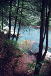
Alabama's first National Wilderness Area, the Sipsey Wilderness,
is located in the Bankhead National Forest. Bankhead is the home of Alabama's only
nationally designated Wild and Scenic River. Comprised mostly of the Sipsey Fork and it's
tributaries, this river system is 61.4 miles in length. Portions of the river are
seasonally suitable for canoeing; access points are located throughout the forest.
Lying partially within Bankhead is the picturesque Lewis Smith
Lake. This 21,000-acre lake, bordered by many high rock bluffs and outcroppings, boasts
over 500 miles of shoreline. Three National Forest recreation areas, Corinth, Houston and
Clear Creek, are located on Lewis Smith Lake.
Among the historical areas found in Bankhead are several
depression era Civilian Conservation Corps (CCC) Camp sites. The CCC enrollees built many
of the forest's roads and picnic areas. Pine Torch Church, nestled deep in the heart of
the Bankhead, still holds services each Sunday morning in a log building dating back to
the 1850's. Pine Torch did double duty as a school building for many decades.
Bankhead National Forest abounds with primitive and developed
recreational opportunities, natural beauty, and numerous lessons in history.
A visit to Bankhead will be a trip of discovery.
Recreation Areas
Six recreation areas are scattered about Bankhead, each offering
a unique experience of its own. Facilities for camping, picnicking, fishing, hiking, and
swimming are abundant, along with possibilities for photography and nature study. All
facilities were designed with the forest user in mind and provide varying challenges for
everyone from the novice to the expert. Visitors will find each area has its own
personality, and with the changing seasons even that personality will change.
Owl Creek Horse Camp and Trail System
Offering nearly 30 miles of trails designed for
horseback riding, the Owl Creek Trail System is unique and is growing in popularity every
day. Starting at the Owl Creek Horse Camp (located on Forest Service Road 262 about 7
miles east of Highway 33) the trail rider may choose from loops of varying lengths. The
camp provides primitive overnight campsites for trail riders on a first-come, first-served
basis.
Clear Creek Recreation Area
The Bankhead's newest, largest and most modern
recreation area, Clear Creek offers facilities for individual and group camping,
picnicking, swimming, boat launching, hiking and biking. Some camping and picnicking
sites, bathhouses, and a portion of the trail system are accessible to persons with
physical disabilities. Amenities to make your stay more enjoyable include an
entrance/information station, water and electric hookups at all camping sites, public
telephones, children's playground, bathhouses, and a recreation vehicle sanitation
station. Clear Creek has become one of Alabama's most popular areas and has many repeat
visitors. Advance reservations are recommended for weekends and holidays.
Corinth Recreation Area
A visit to Corinth is a trip back to nature. Corinth,
with its relaxing forested setting, has been popular for many years for picnicking and
camping in tents or small recreation vehicle campers. Located on Lewis Smith Lake, Corinth
provides excellent access to water-based activities such as swimming, fishing, boating,
and water skiing.
Houston Recreation Area
Located on Lewis Smith Lake, Houston Recreation Area is
a perfect quick getaway from urban life. It is excellent for both individual and family
recreational pursuits and offers camping, picnicking, swimming, and fishing.
Brushy Lake Recreation Area
Nestled into a more remote setting of Bankhead, Brushy
Lake is a retreat from the hustle and bustle of everyday life. A quiet tranquil place,
Brushy Lake offers everything from camping, picnicking, or relaxing, to fishing in it's
own 33-acre lake.
Sipsey River Picnic Area
Picnicking; fishing; drinking water; sanitary facilities
and hiking trail.
Sipsey Wild & Scenic River
Canoeing; 61.4 miles of seasonal canoeing on a selected
section based on stream levels. Call the District Office to receive information on stream
levels.
Hurricane Creek Shooting Range
This shooting range can accommodate rifles or pistols.
Some activities beyond the Recreation Areas are the
Natural Bridge
(the longest east of the Rockies), Little Natural Bridge, Looney's Tavern
Amphitheater and Park, Houston Civil War Jail, and Pine Torch Church (so
called because the worshipers used "pine torches" to light their
1850 constructed church).
Looney's Tavern Amphitheatre and Park
In case you weren't aware, in the 1860's, a large number
of the Winston County residents, in the southern portion of the Bankhead, refused to side
against Old Glory, and attempted to withdraw from the state of Alabama and form the Free
State of Winston. Winston County was hardworkin' Appalachian farmland and not river-bottom
planation land. The residents did not agree with the need to offer their sons' lives to
preserve a way of life they did not share. At a community meeting held at Looney's Tavern
on July 4, 1861, the 3000 residents of Winston County vowed to maintain neutrality and
peace. However, Winston County was not able to achieve either. During the 1860's life was
hard for those Jacksonian Democrats, both economically and politically. The story of this
period in American history is told in plays at the Looney's Tavern Amphitheatre and Park.
The Houston campground is closest to the Tavern.
Little Natural Bridge
North of Houston Recreation Area, on County Route 63, is
the Little Natural Bridge. A paved trail leads the visitor to an up-close look at a
natural bridge. Visitors can explore under, around and through this beautiful sculpture of
nature. Other examples of how water is nature's principle sculpting tool are found along
the delightful Ravine Trail in the Clear Creek Recreation Area. Hikers along this trail
can envision long ago people using a rock shelter for protection from foul weather or as a
camping place during hunts.
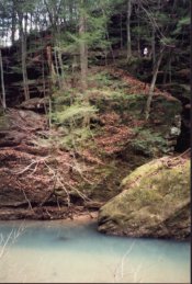
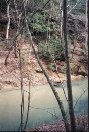
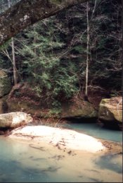
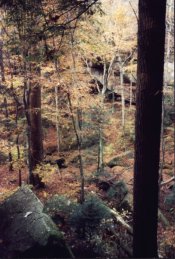
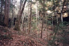
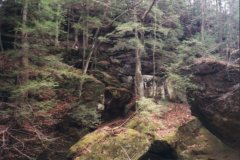
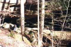
Hiking
Hiking opportunities abound in Bankhead. While
hiking, one can expect to find tall trees, flowing streams, picturesque rock bluffs, and
abundant wildlife. The rock cliffs rising from the waters of Lewis Smith Lake and along
the canyons of the Sipsey River are outstanding examples of Bankhead's rugged beauty.
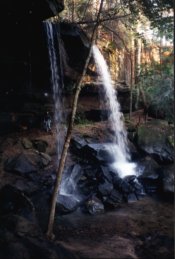
Streams in Bankhead often cascade over steep rock faces into deep gorges, forming
beautiful waterfalls. These natural wonders can be reached by way of the numerous hiking
trails provided in Bankhead.
Alabama's first National Wilderness Area, the Sipsey Wilderness,
is located in Bankhead National Forest. Designated by Congress in 1975, the Sipsey
Wilderness originally contained 12,726 acres, and in 1988, Congress increased the area to
25,906 acres.
The Sipsey Wilderness and Trails
The 25,906 acre Sipsey Wilderness enjoys special protection
designed to restore and preserve the natural ecological conditions of the area. The Sipsey
provides the wilderness visitor with a primitive recreation experience and outstanding
opportunities for solitude. Hiking, camping, hunting and fishing are permitted in the
Sipsey. Horseback riding is allowed on trails specifically designated for horses. In order
to protect the wilderness experience and environment, mountain bikes and motorized
vehicles are not allowed inside the Sipsey's boundaries.
The Sipsey Wilderness is found in the southwestern portion of
Lawrence County. Many people enjoy the beauty of Lawrence County's greatest
resource, the Sipsey Wilderness Area of Bankhead National Forest that lies in the heart of
the Warrior Mountains. Sipsey River Picnic Grounds are located on Sipsey Fork near
the Cranal Road, the south border of the wilderness. Many people hike and backpack
in the Sipsey Wilderness, as well as drive along Highway 33 and the Cranal Road to enjoy
the splendors of the forest.
Sightseeing, hiking, canoeing, backpacking, and horseback riding
are only a few of the many outdoor recreational activities available to Lawrence County
residents, as well as visitors from all over the Southeastern United States.
The Sipsey Wilderness is the place for those who want to get away from modern conveniences
without the sound of traffic, telephones, and TV's, but instead listen to the songs of the
warblers, the hammering beaks of woodpeckers, the hoot of the great horned owl, the howl
of the lone coyote, and the sound of water running over rocks and boulders in the many
streams flowing through this portion of the Warrior Mountains.
The US Forest Service has designated and established trails for
hiking, horseback riding, and horse or mule drawn wagons. These trails and roads
provide access to secluded sandstone cliffs, wonderful waterfalls, fantastic fall foliage,
beautiful wildflowers, and tremendous trees. Designated hiking trails begin at
Borden Creek Bridge on the Bunyan Hill Road, Sipsey River Picnic area and at Thompson
Creek Bridge on the Northwest Road. A hiker can spend a few hours or a few days
hiking the trail system in Sipsey Wilderness. McDougal Hunter's Camp is a campground
for those hunting or hiking the area. A system of horse trails begins at Owl Creek
Horse Camp and contain many miles of connected riding loops. The 1988 addition to
Sipsey Wilderness can be used by horse or mule drawn wagons. The wilderness access
to wagons provide rides for young, old, and disabled individuals through the most scenic
portion of our Warrior Mountains.
In addition to various types of trails and roads in the Sipsey
Wilderness Area, primitive wilderness camping is available to those who really want to get
away without driving for hours. Two sites which I would strongly recommend for
wilderness camping is Bee Branch and Ship Rock, a totally isolated area with great
sandstone bluffs and shelters located on either side of the canyon.
McDowell Cove
McDowell Cove of Bankhead National Forest is located primarily in
Section 4 of Township South and Range 8 West. McDowell Cove is on the upper
drainages of Flannagin Creek and is one of the most beautiful canyons in the Warrior
Mountains. The Cove lies between Mountain Springs Road on the eastern ridge, Gum
Pond Road located on the western ridge, and the Ridge Road on the northern ridge.
In the center of McDowell Cove, an Indian mound if found in the
front yard of Jack McDowell's old log house. The flat level top of the mound
actually lies immediately east of the dog trot style log cabin. The sides of the
mound only rise some four to five feet at the highest point. Around the mound,
numerous flakes of flint can be found. Throughout McDowell Cove, flint provides
evidence of long term occupation of the cove by Indian inhabitants.
The area had been known as Wallis Cove, Wilkerson Cove and after
many of the other families that inhabited the area in the past; however, since Jack
McDowell was the first Forest Ranger of Bankhead and made the Cove his home, the area is
widely accepted as being McDowell Cove.
Wallis Cemetery, named after some of the Cove's first residents,
contains the gravis of four Civil War soldiers. Two old houses still stand in the
flat valley: Jack McDowell's home and the Wilkerson home. The old Sally Ann
House was sold to a Mr. Norman Tidwell from Winston County and moved during 1993.
Open pasture or farm land located in the Cove is privately owned.
Bee Branch Canyon
Bee Branch of the Sipsey Wilderness Area is located primarily in
Section 26 of Township 8 South, Range 9 West. Bee Branch is a deep canyon located
east of Sipsey Fork. The area is probably the most primeval site in the Warrior
Mountains. Most of the canyon was protected by the US Forest Service as early as
1919.
Bee Branch is a forked canyon with seasonal and beautiful
waterfalls in each fork. The Bee Branch Falls plunge some 50 feet above the canyon
floor. Both forks are virtually box canyons forming a small creek that flows into
Sipsey Fork. The eastern fork of the canyon features the largest yellow poplar in
the Southeastern US. The whole gorge is a botanical garden of virgin hardwoods and
growth.
Tar Springs Hollow
Located in the upper portion of Capsey Creek, once known as
Capp's Creek, is a place not found elsewhere in William B. Bankhead National Forest.
The creek begins at Cave Springs on Hwy 41 and on the Leola Road at Basham
Shelter and Spring. The area, not noted for the two head water springs, is unique
because of the two springs downstream in the middle of the big hollow. This unusual
site found on Capsey Creek is known as Tar Springs Hollow.
Capsey Creek is a tributary to Brushy Creek which empties its
waters into Sipsey Fork on Smith Lake. The Tar Springs Hollow on Capsey Creek
contains two mineral tar springs which are located about one quarter mile apart in the
Southwest 1/4 of Section 26, Township 8 South, and Range 6 West.
According to the Alabama Geological Survey as reported by
geologist Jonathan Hunter and made available by Mr. Leon Hightower, "These springs,
years ago, were places of a resort for the afflicted who drank their waters and swallowed
their tar or maltha, made into pills, and supposed that they were greatly benefited
thereby. The hotel and cottages for the accommodation of the visitors to these
springs are said to have stood on the hill just south of this lower spring. Both of
these springs, however, have been spoiled by blasting them for asphaltum."
The article also indicated that barrels of tar were collected in
holes made in the floor of the springs and shipped off. In addition to the Tar
Springs, oil wells were drilled in 1865 and 1867 that were between 700 and 800 feet deep.
The geological survey reports that Jonathan Watson probably drilled and got
oil out of the wells in Tar Spring Hollow.
According to material furnished by Mr. Rayford Hyatt, the Tar
Springs Hollow Road was one route many settlers and visitors took to the Tar Springs
Resort. The early road led from Melton's Bluff to Oakville, then to Poplar Log Cove
where the road forked. The eastern fork was the main route and was the Black Warrior
Town Trail or Mitchell Trace. The south fork became known as the Tar Springs Hollow
Road and traveled south up Wiggings Hollow. The road crossed the High Town Path east
of Center Church and passed down a long ridge into Tar Springs Hollow.
From the 1800's through the early 1900's, prior to the National
Forest status the land has today, many people lived in the area of Tar Springs Hollow.
Cave Springs Cemetery and Center Cemetery contain the remains of many who called
the Tar Springs Hollow area home.
It appears from examination of the tombstones in Cave Springs and
Center Cemetery, that many of the people were descendants of the Creek and Cherokee
Indians, the earlier inhabitants of the area. Many of the family names of those who
presently compose the Lawrence County Indian population are found in the old cemeteries.
Poplar Log Cove
Poplar Log Cove of the Warrior Mountains is located primarily in
Section10 of Township 8 South and Range 6 West. Poplar Log Cove is on the upper
portion of the West Fork of Flint Creek in Bankhead's northeastern portion. Black
Warriors' Path traversed through the Cove and passed by the Poplar Log Cove Spring which
forms the headwaters of West Flint Creek.
Based on archaeological evidence, Poplar Log Cove was utilized by
Indian people as early as the Paleo Period. A Paleo scraper and Decatur Point were
found and identified near the center of the Cove. Poplar Log Cove was settled in the
early 1800's by Indian mixed bloods and white people. The Cove was flat with broad
fertile valleys which were farmed in patches of cotton and corn. Today, most of
Poplar Log Cove is privately owned but remains one of the most beautiful valleys of the
Warrior Mountains.
Indian Tomb Hollow
Indian Tomb Hollow is located primarily in Section 2 of Township
8 South, Range 7 West on the northern edge of Bankhead National Forest. In the
distant hollows of Indian Tomb Hollow, the wood hen can be heard as the evening sun sinks
behind the bluffs. Three gracious waterfalls of the southwest fork echo eternal
sounds that formed the sandstone canyon containing vertical walls reaching to the sky.
Looking down the canyon toward the northeast sandstone bluffs on either side of the
canyon causes one to be in awe of the area because of its beauty.
Early settlers and Indian mixed bloods settled to the north and
west of the hollow's southwestern fork. Several people lived for a while in the old
High House located on a small knoll at the mouth of Indian Tomb. Families of the
Warrior Mountains would enter the hollow from Chestnut Ridge, Bulah, and High House Hill
not only to view and enjoy the beauty of the area, but to dig roots, herbs, and hunt.
It was in this same tradition that I was first introduced by my granddad
Authur Wilburn, to the mysterious but beautiful Indian Tomb Hollow.
Mr. G. H. Melson tells of experiences he had as a small boy in
Indian Tomb Hollow and is a wealth of information concerning an Indian fight occurring
near the mouth of the famous canyon. He tells of his father working on the old
plantation and passing down stories through many generations about the Indians of the
area, the black slave cemetery, and the early settlers who called the area home.
Over many years, the Gillespie family has traditionally been
drawn to Indian Tomb. Not only does the family consider the area a sacred Indian
burial site, but their ancestor, James Richard Gillespie, a veteran of the Creek Indian
War, is buried in the Gillespie Cemetery. In addition, Gillespie Springs and
Gillespie Creek, which runs through Indian Tomb Hollow, are named after the Gillespie
Family of Lawrence County.
A story called the "Battle of Indian Tomb Hollow" or
"Ittaloknak" was originally printed in The Moulton Democrat in November 1556.
The articles compose a beautiful love story that describes a fierce fight in
Indian Tomb between the Creek and Chickasaw inhabitants of the Warrior Mountains.
Hiking in The Sipsey Wilderness
Sipsey Images From Other People
Bill Solomon's Sipsey Page
The Alabama Trails Association
Maps:

EYRYE: http://www.eyrye.com/

A new Trail Map is available for the Sipsey Wilderness.
This topographical map illustrates unmarked and maintained
trails in a useful scale.

	Backcountry Trail Surveys
	PO Box 5224
	Huntsville, Al 35814
	trails@terragis.com