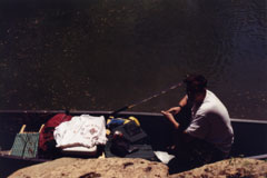
The Sipsey Fork
Bankhead National Forest
Sipsey Fork Water Level
The Sipsey Fork is located in
Bankhead National Forest and runs from the Sipsey Wilderness into
Smith Lake. The Sipsey Fork begins where Thompson Creek and
Hubbard Creek merge within the Sipsey Wilderness. The Sipsey Fork
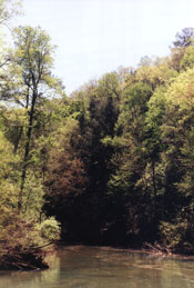
is a peaceful float trip combined with the beautiful scenery and
great camping that distinguishes the Bankhead from other National
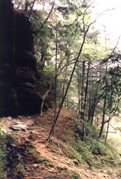
Forests. Canoeing the Sipsey Fork you will pass magnificent walls
of rock which have been carved for thousands of years by the
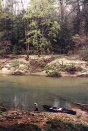
erosive power of water. As the Sipsey Fork begins to merge with
Smith Lake the creek becomes non-turbulent and wide. This area
must be paddled but offers a slow-pace if interested in fishing
or just a slow-paced trip.
The West Fork of the Sipsey has many challenges such as logjams
and rapids. During the rapids and other hazards, the camera was
in its case. The pictures consist of the majority of the trip
but do not show the shoots, rapids, and logjams you may encounter.
The logjams are mostly a concern on Thompson and Borden Creek.
Mainly Thompson.
Sections of the Sipsey Fork:
Section C (Upper Sipsey Fork)
makes a great day trip as well as Section D (Lower Sipsey Fork).
Section C has a diverse combination of canoeing enjoyment which
consists of many scenic rock formations, flora, rapids,
shoals, and deep water. Section D offers many large and scenic
cliffsides but consists mostly of paddleing in contrast to
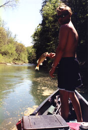
Section C. Both Section C and Section D offers fishing for Stripe
Bass, Largemouth Bass, Smallmouth Bass, Rock Bass, Bream, and
Crappie.
Section A (Borden Creek) combined with Section C (Upper Sipsey
Fork) make a great overnite trip with plenty of camping on both
sides of the water. Section B (Thompson Creek) combined with
Section C offers a longer overnite trip as well as a some rapids
and a shoot. Section C combined with Section D (Lower Sipsey
Fork) offers a good 2 night trip or a swift overnite trip.
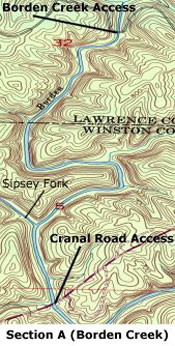
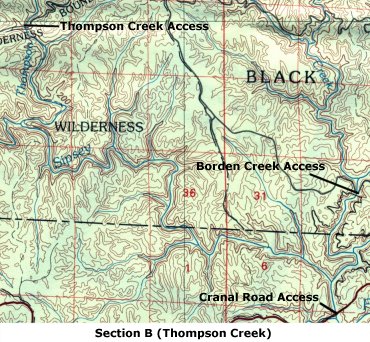
Section A (Borden Creek):
Section A is mostly on Borden
Creek and a few hundred yards on The Sipsey Fork. The put-in for
Section A is at Borden Creek Access
and the take-out is at the Cranal Road Access.
The Borden Creek is shallow but becomes deeper as you approach
the Sipey Fork. Continue on Borden Creek
until reaching the Sipsey Fork which is slightly larger than
Borden Creek as they merge. The take-out is just a few hundred
yards after merging with the Sipsey Fork at the Cranal Road
Access.
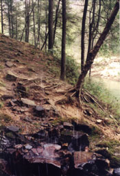
The scenery of the Borden Creek is very scenic, you will see
large boulders in and around the creek. The large cliffs which
characterize the Sipesy Wilderness and the Bankhead National
Forest hang just above the floodplain's of Borden Creek. At some
points these cliffs meet the edge of Borden Creek along with
small water tunnels and large boulders. Borden Creek has many
sandbars and small passages which may require getting out and
pulling the canoe thru during the dryer months. The entire left
side of the creek is paralleled by trail FS200 which offers many
campsites utilized by backpackers. The right side of the creek
has an unnamed trail and offers many areas for camping as well.
The unnamed trail on the right is often overlooked by backpackers
and offers more privacy and less traffic than FS200.
Section B (Thompson Creek):
Section B begins on Thompson Creek at the
Thompson Creek Access
and ends on the Sipsey Fork at
the Cranal Road Access.
Thompson Creek is very scenic offering a
slow and peaceful float with many areas for a lunch or camping.
As you reach deeper water and take a 180 degree turn to the right
you will pass a creek which is a combination of Parker Branch,
Quillan, and Hubbard Creek. This junction is the headwaters of the
Sipsey Fork. The first few hundred yards of the Sipsey Fork are
deep water which quickly turns to rapids and a shoot but is not a
problem unless unusually high or low water. There are great
campsites just before and during the shallow rapids and shoals.
The Sipsey Fork continues for a few miles and join with Borden
Creek and shortly ends at the Cranal Road bridge and the Cranal
Road Access.
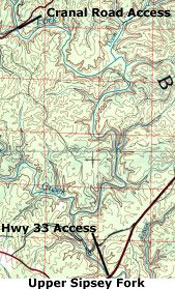
Section C (Upper Sipsey Fork):
This section begins at the Cranal Road Access
and ends in 8.8 miles at the Hwy 33 Access
point. This trip offers the most diverse scenery and water
conditions of all sections. From the Sipsey River Recreational
the river is about 35-50 feet and stays around this width the
entire section. The first two miles you will see large boulders
that have been carved from the bluffs above which are visible
through the Poplar, Oak, and Pine Trees of the floodplain.
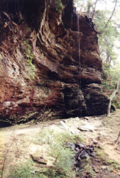
Eight miles from the Cranal Road Access there is a large cliff that
towers vertically from the waters edge. This section has camping
areas which are isolated but are grown-up and hard to spot from
the water. You will notice where an old bridge used to cross the
river by concrete randomly located on the sides of the river,
this has been refered to as Low Water Bridge but is no-longer
standing. Soon after you will come to Hwy 33 bridge and Hwy 33
Access where you will take out on the left. Just after you pass
the bridge way above on the cliffs there is a small waterfall
which drops about 75 feet into the river.
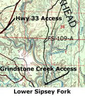
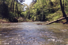
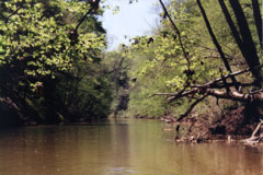
Section D (Lower Sipsey Fork):
Section D begins at the Hwy 33 Access and ends 5.4
miles at the Grindstone Creek Access.
This trip is the most scenic of the sections but is mostly a paddle
trip rather than a float. At the put-in and just below are the
most scenic cliffsides of the Sipsey Fork, there are waterfalls
plunging off the top of these cliffs directly into the creek some
75-100 feet below. The Sipsey Fork begins from the Cranal Road
Access at around 50 feet and widens to around 200 as it
approaches its destination of Smith Lake. Expect the current to
die down at around 2 miles and begin paddleing until reaching the
take-out. At around 2.5 miles there is a large under-cut
cliffside on your right and then as you go around a bend they are
on the right. There are small waterfalls off of these cliffs
during wetter months. You will soon pass Payne Creek on your
left. You will pass 2 small streams just after on your left and
then approach high bluffs on your right which stetch down the
river for about a mile. Just past these high bluffs look for
Sandy Creek on your right and just after that the take-out on the
left.
Access Points:
Thompson Creek Access:
The Thompson Creek access can
be located within the Sipsey Wilderness and is widely used by
hikers for 2 main trails within the wilderness area. To get to
the Thompson Creek access from the Ranger Station in Rabbittown
on Hwy 195 turn at the Ranger Station onto county road 23 heading
north. You will pass county road 60 (Cranal Road) on your right
and soon after the road will turn to dirt. Continuing north on 23
you will pass a church and then a turn to your left which seems
to be a fork (Forst Service 203), continue to strait which is a
right-hand direction. Next turn to the right on FS208 and follow
it to the Thompson Creek bridge which is the access area for
Thompson Creek. The best put-in is on the side of the bridge you
will be approaching on the left. Many horseriders let their
horses drink here so there is a beaten path all year around.
Borden Creek Access:
The Borden Creek access is
located within the Sipsey Wilderness and is used by hikers to
accessing trail 200 and 224. To get to the Borden Creek access,
continue strait past the Sipsey Fork bridge on Cranal Road (read
Cranal Road Access) and turn left on FS 224. FS 224 will dead end
just before Borden Creek and the bridge. Put in on the left side
of the bridge.
Cranal Road Access:
The Cranal Road access can be
located within the Sipsey Wilderness and is used by hikers
accessing the FS trail 200 and 209 as well as the Sipsey River
Recreation Area. To get to the Cranal Road access from the Ranger
Station in Rabbittown on Hwy 195 turn at the Ranger Station onto
county road 23 heading north. Take the first paved right turn
onto Cranal Road or county road 60. Continue on Cranal Road until
you cross the Sipsey Fork bridge. Just after the bridge turn
right into the parking lot and park in the first parking area.
There is a smaller bridge just under the main bridge for the
parking lot designed for the Recreation Area's day use. Put the
canoe in on the left side of the smaller bridge.
Hwy 33 Access:
Hwy 33 access is located within the
Bankhead National Forest and is located on Highway 33. To get to
the Hwy 33 access follow Hwy33 from Double Springs until you
cross a bridge over the Sipsey Fork. Just after the bridge take a
right onto a gravel parking area. I leave my car in the parking
lot but to put-in or take-out I drive my car down the gravel
trail which leads to the water. At the end of the trail you will
have to walk down a water drainage area and put in on the right
side of the drainage. Actually my car is a truck which is
reccomended for using this road especially in wet weather. It
wouldn't be far to carry the canoe if you aren't sure about the
road (70m).
Grindstone Creek Access:
Grindstone Creek access is located
within the Bankhead National Forest and located on FS109-A. To
get to the access area follow Hwy 33 from Double Springs past the
Hwy 33 access area and turn right on Hwy 76 or FS 234. Follow Hwy
76 until it dead-ends on Hwy 63 and turn right. Look on your
right side for a dirt road FS109. Take a right on FS 109 and
follow it until you reach a right hand turn which is FS109-A.
Follow FS 109-A to the Sipsey Fork and put-in or leave car for
take-out. This is a long road and a 4wd is reccomended for wet
weather.
The Sipsey River's Flow (ftł/s) and Stage (ft) can be obtained at
The United States Geological Survey's
web-site.
The minimum Stage (ft) I currently recommend for canoeing this
river is 4.0 ft. You will probably drag the bottom of your canoe
if the Stage is below this point.
Maps:

EYRYE
EYRYE Canoe Maps